City Centre Outside Inner Ring Road
Note that you can click on any old picture to see a larger version
St Luke's Rd
|
|
 |
 |
| 1955 |
2006 |
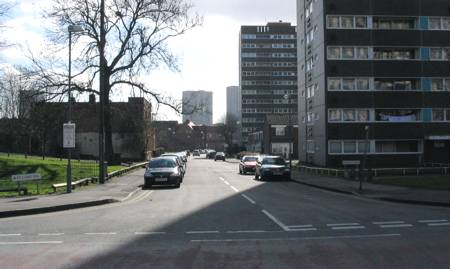
| There
is little in my father's collection of photo's that demonstrates the
vast changes that took place to the city's residential areas.
This shot is all the more important because of that. St Luke's
Road is just off Sherlock Street, near to the old site of Matthew
Boulton College. There's a real sense of community in the 1955 shot with the rows of terraces and the corner shops. The same cannot be said of the 2006 shot, with soulless tower blocks in place of the houses. Sue got in touch to point out the the building on the curve of the road that provides a link between the shots was not a factory, but had once been Dr Middlemore's Home. She also said that, "It ceased to be an emigrating home when Canada refused to take waifs and strays and only accepted 14-yr-olds who had completed their education". There is some fascinating history about the home here. |
|
Bristol Road Nr Bristol Cinema
|
|
 |
 |
| 1961 |
2005 |
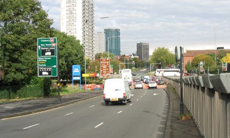
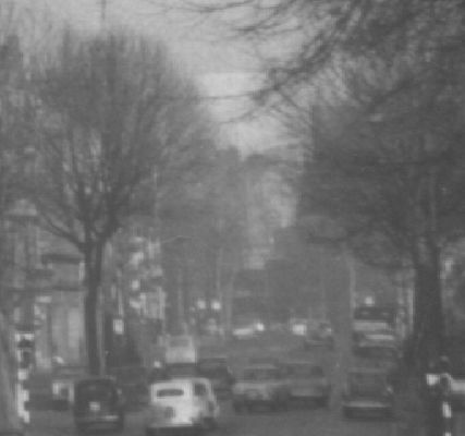
| This
picture caused me a great deal of confusion! The note on the back
said, "Bristol Rd Nr Bristol Cinema", and I had a vague recollection of
a cinema at the junction of Bristol Road and the Middle Ring Road
(where McDonald's is now). But I couldn't believe it could
possibly be the same place... Maybe it was Selly Oak - I remembered a cinema there too. But that didn't look possible. Maybe it was Northfield? No, that wasn't right either. The only place it could be is the place I thought it couldn't possibly be - no wonder I was confused! Studying the picture in detail didn't provide much help. It's a little bit out of focus and overexposed so I couldn't make out any words on signs that would help. I could see the pattern of roads and an old map confirmed that I could be on the right lines. On the right hand side there are some windows in a roof - could that be St. Luke's church? No! When I checked, there were no windows in the roof. Again, an old map came to the rescue by showing another church (a Baptist chapel) next to St. Luke's and closer to the place where the photo was taken but I could find no picture of it on the net. I just accepted that it was probably still in place in 1961 and was blocking the view of St.Luke's roof. On my bus journeys to and from the city I eyed up the location. It was fairly easy to work out the old path of the road where Bristol Street becomes Bristol Road and this backed up my hunch. In the end I just went to the place I thought it was and took the modern photo. Back on the computer and with both pictures zoomed in I scoured the images for a common link. Hang on - that tree on the left... The branches look like the tree on the old picture! I've shown the 'evidence' below for you to judge. As an aside, note how much detail is contained on the old print. Update: Thanks to all those who got in touch to say that I was right in my conclusions! |
|
 |
 |
Horsefair |
|
 |
 |
| 1962 |
2005 |
| You may
not be aware of it but Horsefair is still there! It's the little
stretch of road from Holloway Circus to Bristol Street. As you
can see, it hasn't really changed much. Except, of course,
everything on the left hand side of the 1962 picture being demolished
and an underpass for the A38 being constructed... I really like the building on the corner of Thorp Street and it's nice to see it's in such good condition today. |
|
Broad St |
|
 |
 |
| 1961 |
2005 |
| The
building to the left is the Hall of Memory. The building to the
right was the old Central TV offices. Everything else has gone... The tall building in the centre of the 1961 picture is Mason College. There is a plaque to mark its location in Paradise Forum near the entry to the Central Library but the plaque was unfortunately covered in beige melamine when the nearby McDonalds got a makeover in 2005 and it can no longer be seen. The 'upturned ziggurat' in the 2005 picture is the Central Library. This building will almost cerainly be demolished when the new Library of Birmingham is complete. |
|
Snow Hill / Constitution Hill
|
|
 |
 |
| 1961 |
2006 |
| Plenty
of common ground here, including the amazing building just left of
centre. They don't make 'em like that anymore! To the right of the modern shot we see yet more city centre apartments. |
|
Corner Legge St / Aston St
|
|
 |
 |
| 1961 |
2006 |
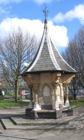
| When I
found the old photo of the fountain at Gosta Green, I felt that I had
little hope of tracing its current location. A 1939 map showed
the spot but it was now part of the Aston University campus.
Imagine my surprise when I turned a corner and found it still there! While taking the modern picture I was approached by a student of the UCE who'd been involved in the landscaping of the current site. It was obvious that the university had been unsure about what to do about it - even a little embarassed that it had to be kept. She asked if I thought it was a good thing that it was still there. Too right it is! It's a important clue to the history of the area. The building to the left of the fountain in 1961 may look like a church but my 1939 map says it was a free library. |
|
 |
 |